home
***
CD-ROM
|
disk
|
FTP
|
other
***
search
/
Digital Atlas of Idaho
/
Digital Atlas of Idaho.iso
/
geog
/
rrt
/
part2
/
images
/
lgrrtp6l.gif
< prev
next >
Graphics Interchange Format
|
2002-03-21
|
27KB
|
358x700
|
4-bit (5 colors)
Labels:
text
|
menu
|
black and white
|
document
|
font
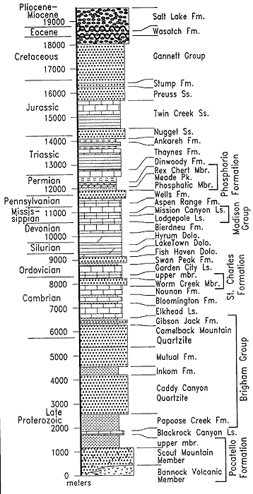
OCR:
Pliocene- Miocene 19000 Salt Lake Fm. Eocene Wasatch Fm. 18000 Cretaceous Gonnett Group 17000 Stump Fm. 16000 Preuss Ss. Jurassic 15000 Twin Creek Ss. Nugget Ss. 14000 Ankareh Fm. Triassic Thaynes Fm. 13000 Dinwoody Fm. Rex Chert Mbr. Permian Meode Pk. 12000 Phosphatic Mbr. Pennsylvanian Wells Fm. Phosphorio Aspen Range Fm. Missis- 11000 Mission Canyon Ls. sippian Lodgepole Ls. Devonian Bierdneu Fm. Group 10000 Hyrum Dolo. Madison Formation Silurian LakeTown Dolo. 9000 Fish Haven Dolo. Swan Peak Fm. Ordovician Garden City Ls. upper mbr. 8000 Worm Creek Mbr. Cambrian Nounon Fm. Bloomington Fm. Formation St. Charles 7000 Elkhead Ls. Gibson . Jack Fm. 6000 Camelback Mountain Quarizite 5000 Mutual Fm. Inkom Fm. 4000 Caddy Canyon 3000 Quartzite Brigham Group Late Proterozoic Papoose Creek Fm. 2000 Blackrock Canyon Ls. upper mbr. 1000 Scout Mountain Member 0 Bannock Volcanic Member Pocatello meters Formation